
Final satellite deployed in BeiDou global navigation constellation
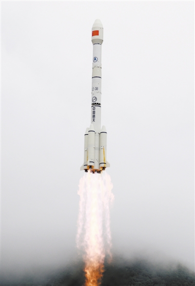
China launched the 55th and final satellite in the BeiDou Navigation Satellite System (BDS) at 9:43 a.m. (Beijing Time) on June 23. This is the third geostationary Earth orbit (GEO) satellite in the BDS-3 system.
Back in its "hometown" - the China Academy of Space Technology (CAST), a subsidiary of China Aerospace Science and Technology Corporation (CASC) - scientists and researchers refer to the GEO satellites as the "Lucky Stars." As the latest satellite is the third, they nicknamed it the "Triple-Lucky Star."
As the main satellite stationed in outer space, the "Triple-Lucky Star" shoulders the responsibility of significantly enhancing the overall technical indicators of the BDS-3 system. With its launch, all 30 satellites in the BDS-3 system are now in place, and the deployment of the satellite constellation is complete.
Making BeiDou stronger
The BDS-3 family consists of 24 medium earth orbit (MEO) satellites, three inclined geosynchronous orbit (IGSO) satellites and three GEO "Lucky Star" satellites.
The three GEO satellites are stationed in outer space, about 36,000 kilometers above the earth, providing enhanced services for the improvement of technical indicators for the BeiDou navigation system.
CAST explained to Science and Technology Daily that the GEO satellites are utilizing the Dongfanghong-3B platform, currently one of the largest satellite platforms in use in China.
GEO satellites feature powerful support capacities, with six capabilities of radio navigation, radio measurements, satellite-based enhancement, precise single-point positioning, power enhancement, and inter-station time synchronization and positioning.
The GEO satellite family has inherited the most distinctive features of the BeiDou system - active positioning and short message communication, which are pioneering creations of the BeiDou system.
Active positioning, whereby two GEO satellites work together and employ radio measurement technology, can not only answer users asking "where am I?", but also tell those monitoring the users' whereabouts about "where they are." This feature can be widely used in search and rescue, fisheries and other fields.
The short message communication ability of the BDS-3 system has been significantly improved, and the number of Chinese characters in a single message transmission has been increased from the previous 120 to 1,200 characters.
As such, there is no need to consider word limits in emergencies, and the situation can be clearly explained in a single message, while additional information such as pictures can also be sent. This means that the system can be used in more application scenarios.
In March, after the second GEO satellite in the BDS-3 system was put in place, the active positioning function under the new BeiDou system was verified, lifting the curtain on the comprehensive upgrade of the radio measurement function. With the arrival of the "Triple-Lucky Star," the three GEO satellites have been reunited in space, stretching a greater distance along the equator to provide services over a wider area along the "Belt and Road" routes.
Creating a 'Chinese soul' for BeiDou
As the final satellite in the global BeiDou navigation system, the "Triple-Lucky Star" has always adhered to the idea of domestic manufacturing, and epitomizes a masterpiece of "made in China."
The scientists and researchers behind the BeiDou project have long understood that the core technologies cannot be asked for, bought or begged, meaning domestic development was the only way.
According to Chen Zhonggui, chief designer of the BDS-3 satellites at CAST, the BeiDou navigation system will provide time references and spatial location references for national security, socioeconomic development, and people's lives. In particular, the system is crucial to both national security and people's lives.
For example, the current hot topic of new infrastructure will be an important direction in the next stage of China's construction and development, for which time reference and spatial location reference are important foundations. "The BeiDou navigation system is the infrastructure for the new infrastructure, the foundation for the foundation," Chen said.
Xie Jun, deputy chief designer of the Beidou system and chief satellite designer, explained that the BDS-1 system solved the most basic problems of satellites, such as solar panels for power supply and distribution, and the rotating mechanism of the control system. Making these core products domestically has given the BeiDou satellites a "Chinese body."
BDS-2 broke the blockade of foreign technologies, and made breakthroughs in several key technologies. These include the overall technologies of navigation satellites, and high-precision spaceborne atomic clocks, meaning the satellite navigation system beats with a "Chinese heart."
Now, BDS-3 is leading the field. The satellite team at CAST proposed the first international inter-satellite link hybrid system in high- and middle-level orbits, which formed systematic solutions with independent intellectual property rights, such as an inter-satellite link network protocol, autonomous orbit determination, and time synchronization. At the same time, China has established an integrated system for the domestic construction of parts and components, all the way from development, testing and verification to application. This allowed the country to completely break the situation whereby it has long relied on imports for core device parts and components, which are controlled by others overseas, and create the "Chinese soul" of the BeiDou navigation system.
With independent intellectual property rights and core technologies, the proportion of BeiDou navigation satellites which are domestically made, either in terms of single satellites or their key components, has now reached 100%.
