
Beijing-3 Satellite Shows Powerful Photography Ability
By Staff Reporters
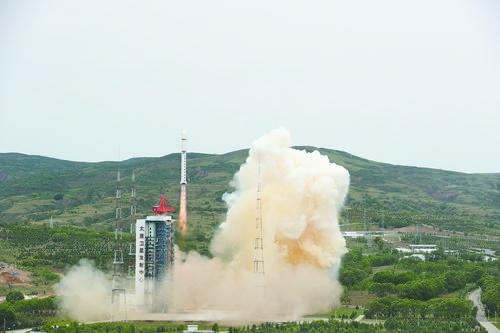
A Long March-2D rocket carrying Beijing-3 satellite blasts off from the Taiyuan Satellite Launch Center in north China's Shanxi Province.
(PHOTO: XINHUA)
China launched 55 rockets in 2021, the most of any other country. Meanwhile, 97 spacecraft were successfully sent into the space. Among all these, Beijing-3, a commercial satellite that orbits the Earth at a height of 500 km above the surface, has a powerful photographic ability.
Beijing-3 is considered one of the highest performance Earth observation satellites. It can take photos with a high-quality spatial resolution of 50 cm, which means that every pixel on your screen is equivalent to 50 cm on the ground, regarded as advanced by international standards. Its performance tests also showed that the satellite was able to take images while its fuselage was twisting at 10 degrees per second. Compared with WorldView-4, the most advanced U.S. observation satellite currently, Beijing-3 has a two to three times faster response time.
As a new-type high-performance optical remote sensing satellite, Beijing-3 can provide panchromatic imagery of a half-meter resolution, and multispectral imagery with two-meter resolution, which means it can distinguish vehicles and other civilian aircraft.
At the same time, Beijing-3 also adopted technologies such as intelligent task planning, intelligent image processing, and intelligent compound control, which enable it to have a strong image acquisition capability and a unique imaging mode. In addition, the satellite supports active push-scanning along rivers, highways and other tracks. In this way, it may obtain a high-definition image of the whole Yangtze River basin in one single transit. It also supports quick multi-angle imaging to get 3D all-round data of surface features.
Beijing-3 is a commercial explorer satellite mainly used in resource investigation, ecological monitoring, fine urban management, disaster monitoring and other aspects. In the meantime, it provides data support for China's key projects. For example, after the rainstorm in July 2021 in Zhengzhou, Henan province, Beijing-3 paid close attention to rivers in the area, significantly contributing to disaster relief and post-disaster reconstruction.